ImageBase
Click on the image for full size view.
| URN | ns3761 |
|---|---|
| Work Type | Photograph |
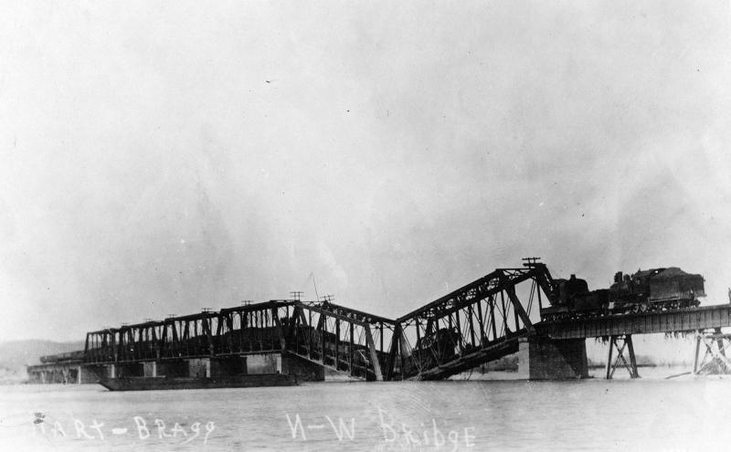
| Title | Train Wreck On The Scioto River Bridge |
| Creator | no creator given |
| Subject | Railroad,Locomotive,Scioto River Bridge,Ohio,Train Wreck,Accident |
| Work Date | Jan-33 |
| Material | Black & White |
| Current Site | CD: NS022 |
| Notes | Scioto River Bridge (Copied January, 1933) It is the Vera Jct. Bridge after a flood in 1913. The flood waters undermined one of the support piers and it sank into the river. Jim Blackstock ____________________________________________________ This is a photo of the 1913 flood damage to Bridge 2000 at VERA JUNCTION , north of Portsmouth, Ohio. This bridge is the beginning of the Peavine, Cincinnati District and spans the Scioto River. The photo is looking north northwest back upstream. Vera Tower and the junction with the Columbus District is about 200 yards to the right. In March of 1913, starting on the 25th I believe, a series of fronts moved one after the other up from the Gulf of Mexico along the Ohio River Valley in a classic weather pattern. The result was torrential rains, falling over the entire Ohio River basin and centered on Coshocton, Ohio. The fronts were only a day apart and the total rainfall was in the one foot to two foot range; the result is now termed a "100 year flood" The flood, due to the shallow nature of the Scioto River valley and the lack of any bedrock, scoured the entire valley taking out the flood dikes in Columbus, washing away the N&W bridge in Chillicothe and the approaches to the bridge on both sides of the river at Glen Jean/Waverly. The flow scoured the base of the pier on Bridge 2000 and undercut the concrete foundation causing the pier to collapse. The cars on the bridge were placed there to weight it down and literally press the bridge down into the earth and subsoil to limit any scouring action. In this case, the weight was insufficient to resist the flow of this flood. I have never found a definitive date for this photograph, but estimate that the photo was taken on the 29th or 30th of March, 1913. The 1913 flood was the highest flood measured up to that time along the Ohio and its tributaries. A similar flood, created by an identical series of fronts occured in 1907 did far less damage. There were similar floos in 1883,1884, then 1933, 1948 , 1964 and 1997. The 1913 flood created widspread damage across ALL of Ohio, half of Indiana and some of Northern Kentucky. All of the railroads in Ohio suffered severe damage with most bridges across larger creeks and rivers washed away. Great sections of track were washed away also. The labor forces mobilized to repair the damage was estimated to be the largest pool of manpower assembled since the Civil War. Most railroads reopened their mainlines within two weeks of the disaster although work continued until the end of summer to completely restore the original tracks. The flood was so extensive that the Pennsylvania RR published a 300+ page book describing the totality of the destruction of their extensive lines through Ohio and Indiana. The political outcome of this flood was a large series of flood control projects funded by the state and federal governments, which was the first time that a large multi-state project had been attempted with federal oversight. Gary Rolih ____________________________________________________ More damage was caused to the bridges on the Scioto River than the Ohio River. The N&W had damage to that bridge at Vera Junction, (as seen in the picture) where the Peavine and Columbus (Valley) line split. The highway bridge across the Scioto River in Portsmouth was also heavily damaged and was replaced. The big flood events of Portsmouth were the 1913, 1937, 1945 the so-called "dry flood", and 1964. I guess there were floods beyond in the late 80''s or 90''s but I wasn''t living there then. A.J. Gemperline Above information received from Jim Cochoran 3/18/02 |
| Format | image/jpeg |
| Date | 19970830 |
| Owner | dla |
| Copyright | dla |
| Source | Norfolk & Western Historical Photograph Collection |
